Heat wave expected across Sacramento Valley this week
A hot week: Heat wave expected across Sacramento Valley
Updated at 9:57 PM PDT Aug 29, 2022
Hide Transcript Show Transcript
OR SHELTER TURNING TO OUR FORECAST RIGHT NOW. HERE’S A LOOK AT THUNDERSTORM ACTIVITY IN NORTHERN CALIFORNIA EARLIER TODAY. YOU SEE IT GOING ACROSS THE SCREEN. THIS IS A TIME LAPSE VIDEO OF CLEAR LAKE THUNDERSTORMS FORM JUST AFTER 12:30 THIS AFTERNOON QUICKLY PASSED OVER CLEAR LAKE AND LAKEPORT. HERE’S CHIEF METEOROLOGIST MARK FINEMAN WITH A LOOK AT THE FORECAST MUCH DIFFERENT IN THE VALLEY. WELL, WE DIDN’T GET MUCH RAIN OUT OF THOSE COUPLE OF LIGHTNING STRIKES THOUGH A NEW EVEN HAD ONE SMALL. FIRE THAT WAS STARTED BY LIGHTNING ON THE SOUTH SIDE OF CLEAR LAKE, BUT NOW ALL OF THAT IS CLEARED OUT. WE HAVE MAINLY CLEAR SKIES AND SACRAMENTO A COMFORTABLE NIGHT ROBERT HE DOWN TO 82 DEGREES. SO WE HAVE CLEAR SKIES. WE HAVE A DELTA BREEZE AND AFTER HAVING A WARM AFTERNOON THAT WE SAW OVER THE WEEKEND. WE’RE GOING TO HAVE ANOTHER VERY COMFORTABLE NIGHT CURRENTLY IN STOCKTON. WE HAVE SUNSHINE. IT’S 84 DEGREES WITH A WIND OUT OF THE NORTHWEST AT 13 HERE TOO. REALLY NICE COOLING TONIGHT. WE WILL GET OVERNIGHT LOWS DOWN INTO THE LOAD. MAYBE MID 60S AND SOME OF THE WARMER SPOTS MODESTO CURRENTLY IS 88 DEGREES WITH SUNSHINE IN FAIRFIELD ALREADY DOWN TO 76. YOU CAN SEE THE MARINE LAYER WORKING THE SOUTHWEST EARLY WIN TO 24 76 DEGREES THIS HOUR IT’S GOING TO BE WELL IT’S GOING TO COOL OFF RATHER QUICKLY IN SOLANO COUNTY TONIGHT AND RATHER WINDY, TOO, BUT THAT’S THE BENEFIT FOR THE VALLEY GETTING A NICE COOL NIGHT AND IN SOUTH LAKE TAHOE, IT’S MOSTLY SUNNY AND 76 THE HIGH TEMPERATURES TODAY WARMER THAN THE WEEKEND, BUT NOTHING TOO HIGH FOR THIS TIME OF YEAR THE 98 IN SACRAMENTO. THAT’S DOWNTOWN SACRAMENTO. WHICH OFTEN RUNS AS ONE OF THE WARM SPOTS AND THE GREATER SACRAMENTO AREA AND JUST AS REFERENCE NOT TOO FAR AWAY AT EXECUTIVE AIRPORT. THE HIGH WAS 93, SO KIND OF A BIG DIFFERENCE THERE, BUT EITHER WAY THOSE TEMPERATURES ARE LIKELY GOING TO BE SOME OF THE COOLEST TEMPERATURES WE SEE THIS WEEK. WE’RE GOING TO KEEP CLEAR SKIES IN THE AREA THROUGHOUT THE NIGHT TONIGHT AND OVER THE NEXT COUPLE OF DAYS. IT DOESN’T LOOK AS THOUGH THE MONSOON WILL BE COMING BACK ANYTIME SOON THE QUESTION FOR LATER ON THIS WEEK IS JUST HOW HOT IS IT GOING TO GET MAYBE NOT SO MUCH THE NEXT FEW DAYS BUT MORE TOWARD THE WEEKEND AND HERE’S THE UNCERTAINTY. IT DEPENDS ON WHERE THIS HIGH IS AND WHERE THE LOW IS OFF THE COAST OVER THE NEXT COUPLE OF DAYS THESE TWO ARE IN FAVORABLE PATTERN TO GET OUR DAYTIME HIGHS UP AROUND THAT HUNDRED HUNDRED TWO RANGE. THEY GET OUR OVERNIGHT LOWS BACK DOWN INTO THE LOW TO MID 60S. AND SO HEADING INTO THE WEEKEND. THERE’S A QUESTION ABOUT WHERE THIS LOW WILL BE AND WHERE THE HIGH WILL BE IF EVERYTHING MOVES A LITTLE BIT FARTHER TO THE EAST WE’LL HAVE MORE MODERATE DAYTIME HIGHS IF EVERYTHING. STAYS A LITTLE BIT FARTHER TO THE WEST WE’LL SEE MULTIPLE DAYS OVER A HUNDRED FIVE. SO THAT’S THE UNCERTAINTY THAT WE’LL SEE BUT THAT’S NOT UNTIL THE WEEKEND IN THE MEANTIME TOMORROW. WE’LL SEE SUNSHINE IN THE SIERRA DAYTIME HIGHS IN THE 80S. ONCE AGAIN WITH OVERNIGHT LOWS IN THE 40S. THE FOOTHILLS WILL DROP DOWN INTO THE 60S TONIGHT HIGHS TOMORROW 90S LIKE 93 IN PLACERVILLE AND 95 DEGREES IN SONORA. NAPA WILL STAY IN THE LOW 80S FAIRFIELD LOW 90S AND FOR THE VALLEY A LITTLE BIT WARMER THAN THAT AS YOU MIGHT EXPECT. WELL STAY IN THE 90S. HOWEVER 98 IN STOCKTON 96 IN MODESTO, AND MAYBE HE’S HIGH AS 98 IN SACRAMENTO AND ROSEVILLE THE NEXT COUPLE OF DAYS INTO THAT HUNDRED HUNDRED TWO RANGE WITH MORE COMFORTABLE OVERNIGHTS AND THEN HERE’S THE WEEKEND STILL SOME UNCERTAINTY ABOUT THAT, BUT WE’RE GONNA SEE DAYTIME HIGHS PERHAPS IN THAT RANGE OF 105 TO 107. SO IF YOU’RE MAKING PLANS FOR LABOR DAY WEEKEND, YOU MIGHT JUST WANT TO THINK ABOUT IT COULD BE REALLY HOT. SO MAYBE DO THINGS IN THE MORNING THAT SORT OF THING TO WATCH OUT FOR YOU. THANKS. HOPEFULLY THAT SHIFT W
A hot week: Heat wave expected across Sacramento Valley

Updated at 9:57 PM PDT Aug 29, 2022
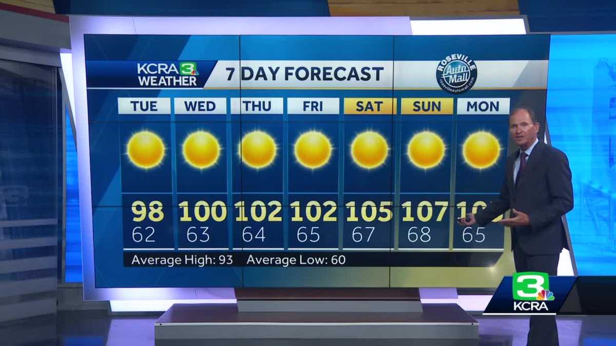
Temperatures over the last few days have been near or below average in much of our area, but that will be changing this week.Many Valley spots will reach the 100-102 range in the Wednesday-Friday timeframe. Overnight lows will drop into the low to mid-60s. At this point, we are looking at the potential for hotter afternoons for the Labor Day weekend. There is uncertainty in the modeling of the weekend pattern, but there is a good chance we will see afternoons in the 105-107 range on Saturday and Sunday.This is the kind of heat you will want to plan around for the holiday weekend. Make use of the cooler morning hours for any strenuous activities and try to limit your outdoor exposure between 3-6 pm Overnights will cool off to the upper 60s.The forecast is likely to change a little over the next few days, but you can make Plan now to try to stay cool this weekend.
SACRAMENTO, Calif. —
Temperatures over the last few days have been near or below average in much of our area, but that will be changing this week.
Many Valley spots will reach the 100-102 range in the Wednesday-Friday timeframe. Overnight lows will drop into the low to mid-60s.
At this point, we are looking at the potential for hotter afternoons for the Labor Day weekend. There is uncertainty in the modeling of the weekend pattern, but there is a good chance we will see afternoons in the 105-107 range on Saturday and Sunday.
This is the kind of heat you want to plan around for the holiday weekend. Make use of the cooler morning hours for any strenuous activities and try to limit your outdoor exposure between 3-6 pm Overnights will cool off to the upper 60s.
The forecast is likely to change a little over the next few days, but you can make plans now to try to stay cool this weekend.