Flooding closes roads, Sacramento power outages
Northern California on Sunday will be mostly sunny but dealing with the aftermath of heavy rain and strong winds on Saturday that caused flooding and knocked out power for thousands.Dozens of people were rescued after their cars got stuck on Highway 99 in Sacramento County when the Cosumnes River flooded the roadway south of Elk Grove. First responders are searching for a missing person. (Watch LiveCopter 3 footage in the video above.)In the Sacramento area, more than 45,000 SMUD customers remained without power Sunday morning, down from 145,000, after winds toppled trees. The Cosumnes River reached its highest level in history and brought flooding to Wilton and parts of south Sacramento County. Residents in Wilton were told to shelter in place if they haven’t already evacuated. Late Saturday, the National Weather Service issued a flash flood warning telling residents along the Cosumnes River at Cosumnes Road and Wilton Road to “seek higher ground immediately” due to the imminent risk of a levee failure. The county confirmed Sunday that there has been a double levee breach.County officials have issued a local state of emergency and said they will be collecting damage estimates. “Sacramento County has been experiencing an atmospheric river that began Dec. 31, 2022, and thus far has resulted in significant transportation impacts, rising creek and river levels and flooding in Wilton,” the county said. Spokesperson Kim Nava said the proclamation will give the county’s director of emergency services the authority to fully use all county resources and personnel to assist with the emergency. They could later seek reimbursement if a state or federal emergency proclamation is issued.In the Sierra, chain controls are in effect on major highways after multiple spinouts and flooding caused traffic delays and closures on Saturday. (Look up the latest road information from Caltrans here.)Interstate 80 and Highway 50 are back open. In El Dorado County, officials ordered evacuations in Cameron Park on Saturday as homes flooded. Some evacuation warnings in the area have since been lifted. Here is the latest forecast for Northern California:Meteorologist Eileen Javora said to expect mostly sunshine on Sunday and highs in the 50s. The next weather system will move in on Monday. This system is much weaker than our recent storm. Rain amounts look to stay within .25-.50 of an inch for the Valley and Foothills. There will be snow in the Sierra with 6-10 inches falling at the summit and snow levels may lower to nearly 3,000 feet. Tuesday stays mainly dry and mostly cloudy. Our next storm moves in later Wednesday and into Thursday. This will likely bring an inch of rain to the Valley with 2-3 inches of rain possible for the Foothills. Snow in the Sierra may be heavy at times. Here are the latest storm updates:10:31 a.m.: Here is where Sac County’s flash flood warning extends. 10:27 a.m.: Some evacuation warnings have been lifted in Cameron Park. 9:56 a.m.: Sacramento County officials confirm a double levee breach in the Wilton area. 9:53 a.m.: First responders are searching for a missing person near Highway 99 south of Elk Grove. Caltrans says that Highway 99 is closed 1.4 miles south of Elk Grove at Dillard Road. It’s also closed to northbound traffic from the junction of State Route 104 to Mingo Road in Galt. 8:27 a.m.: I-80 is back open for Sierra travel.8:24 a.m.: SMUD is working to restore power but more than 43,000 people are still in the dark. 12:47 a.m.: Here’s a look at precipitation totals. 12:45 a.m.: Highway 50 is back open but I-80 remains closed. 12:43 a.m.: SMUD’s outage map shows more than 88,000 customers still without power. 12:30 a.m.: The National Weather Service in Sacramento issued a flash flood warning late Saturday for residents in a part of Wilton to seek higher ground due to the imminent risk of levee failure.The warning, which was issued after 11 p.m., is for residents along the Cosumnes River at Cosumnes Road and Wilton Road.8:33 p.m.: SMUD told KCRA 3 that power was out for 145,000 Sacramento area customers due to heavy windstorms causing trees in the area to fall and knock down power lines. There is not yet a timetable for when power lines will be back up. 6:27 p.m.: Caltrans is telling people not to travel to the Sierra tonight on I-80.6:14 p.m.: A viewer shared video showing flooding on Highway 99 in Modesto. 5:35 p.m.: Here’s a look at some of the storm impacts today across the region. 5:33 p.m.: Liberty Utilities says there are more than 7,000 customers without power in South Lake Tahoe. 5:31 p.m.: Meteorologist Dirk Verdoon looks at rising water levels on the Cosumnes River5:09 p.m.: KCRA 3’s Michelle Bandur reports that 150 people are under an evacuation order in Cameron Park. 5:08 p.m.: Sacramento County issues a proclamation of local state of emergency. The county’s office of emergency services will collect damage estimates. 4:28 p.m.: Part of Soda Springs Road in Nevada County is closed for flooding.4:17 p.m.: Here is an update for Highway 50.4:10 p.m.: The El Dorado County Placerville Library is now closed as a temporary evacuation center, but the Cameron Park CSD is open at 2502 Country Club Drive. 4:05 p.m.: Meteorologist Dirk Verdoorn gives an update on where things stand with rain and flooding. 3:59 p.m.: Here’s an update from Placer County.3:55 p.m.: KCRA 3’s Lee Anne Denyer has an update on what’s happening in Wilton. 3:52 p.m.: Highway 50 remains closed between Pollock Pines and Meyers due to flooding. I-80 is closed from Colfax to the Nevada State Line due to multiple spinouts. Get the latest from Caltrans. 3:37 p.m.: Sacramento County emergency officials say that residents in Wilton should now shelter in place if they haven’t already left the area. Read more. 3:17 p.m.: Here’s a view from Jackson. 2:29 p.m.: Here’s a look at flooding in Placerville.KCRA’s Michelle Bandur explains more in the video below: 2:27 p.m.: PG&E says there are more than 4,720 customers affected by an outage in Stockton.2:13 p.m.: The Amador Fire Protection District says that they have responded to multiple water rescues and have assisted Jackson Fire with multiple flood calls. Officials in Amador County advise people to stay home and avoid travel. The Amador County Sheriff’s Office of Emergency Services has opened a temporary evacuation point at the Italian Picnic Grounds. See below for road closures in the county. 2:11 p.m.: Here’s a look at how Arcade Creek, Cosumnes River and Deer Creek have risen above flood stage. 2:05 p.m.: Here are more updates from Caltrans on road closures. 2:02 p.m.: Arcade Creek in Sacramento County has reached the flood stage.1:59 p.m.: El Dorado and Sacramento Counties are adding more sandbag locations. Sacramento County’s new sandbag location is the Point Pleasant United Methodist Church, at 3329 Point Pleasant Road.1:56 p.m.: The El Dorado County Sheriff’s Office has ordered evacuations for Cameron Park in the area between Cameron Park Lake and Piper Court and Salida Way and Bonanza Drive. Placerville Library is open as a temporary evacuation center at 345 Fair Lane, Placerville.1:53 p.m.: Sacramento County’s Office of Emergency Services warned people who live in Wilton to evacuate the area on Saturday due to concerns of rising water blocking off roadways.Sac County OES said in a release that there is an evacuation center in Elk Grove at the Wackford Community Center located at 9014 Bruceville Road. The Cosumnes River level is continuing to rise throughout the day and is expected to crest above flood stage at 17. 5 feet around 5 p.m.KCRA 3 meteorologist Eileen Javora said that the river hasn’t reached this level of flooding since 1997.Read more here. 12:42 p.m.: El Dorado County announced where road closures are currently.11:30 a.m.: Cameron Park has flooded, causing some to leave the area. 10:42 a.m.: Highway 50 is now being closed at Sly Park Road and at Meyers due to flooding. 10:38 a.m.: NBC Bay Area reports thousands of people without power, roadways flooded in San Mateo and mudslides near Fremont, among other issues. 10:32 a.m.: Two people were rescued from the island in the middle of Laguna Creek in Elk Grove, Cosumnes Fire Department officials said. 10:30 a.m.: All traffic is being held on westbound I-80 at the Nevada State Line due to spinouts over Donner Summit, Caltrans says. Highway 50 is closed from Ice House Road to Meyers in El Dorado County due to flooding. Highway 49 is closed from San Ridge Road to Amador County. Highway 89 is closed around Emerald Bay. 9:53 a.m.: The Cosumnes Fire Department says some people are stuck on a temporary island in the middle of Laguna Creek in east Elk Grove. 9:33 a.m.: Here’s a look at some of the other storm-related stories we’ve been following. Sacramento area parks closed ahead of wet weekend weather as ‘proactive’ measureSan Joaquin Valley officials, residents prep for possible areas of floodingSacramento County officials push to reach people experiencing homelessness ahead of potential floodingSeveral teens rescued from tree limbs after car gets stuck in flooded area of Sacramento County’Don’t drive in water. Period’: Northern California drivers warned about potential for flooded roads9:28 a.m.: Here’s a look at Deer Creek this morning. 9:22 a.m.: Chief Meteorologist Mark Finan says flooding is expected later in Wilton and south Sacramento County. [/twitter]9:09 a.m.: Here’s an update on Sierra chain controls and traffic issues. Interstate 80: Eastbound I-80 traffic is being held at Nyack due to multiple spinouts. Chains are required from Nyack to the Nevada State Line.Highway 50: Chains are required from Twin Bridges to Meyers. Caltrans’ camera shows eastbound Highway 50 closed at Ice House Road, west of Whitehall. KCRA 3 is trying to learn more about this. 8:48 a.m.: In the videos below, KCRA 3’s Mike TeSelle gives an update from Arcade Creek at Winding Road. The creek is swelling but has not caused flooding at this time. 8:46 a.m.: In the video below, Meteorologist Eileen Javora gives an update on rain totals so far and you can see water flowing from the Foothills down Deer Creek in eastern Sacramento County. 8:37 a.m.: Stockton police warn drivers to stay away from the Hammer Lane underpass at the railroad tracks east of Lorraine Avenue. 8:34 a.m.: El Dorado County fire officials warn about roadway flooding and rock slides. 8:09 a.m.: KCRA 3’s Mike TeSelle has an update on a downed tree in the roadway in Carmichael. 8:08 a.m.: An update on Folsom Lake. 7:55 a.m.: Viewer Nancy Riedell in Citrus Heights sent this photo of what conditions look like at Arcade Creek. 7:35 a.m.: Reports of flooding on roadways this morning. 7:39 a.m.: Chain controls are in effect on I-80 eastbound from Kingvale in Placer County to Hirschdale Road in Truckee, Caltrans said.Westbound chain controls are from Truckee to 4.7 miles west of Kingvale.Chain controls are also in effect on Highway 50 from Twin Bridges to Meyers in El Dorado County. Track the latest highway information here. 7:36 a.m.: A warning to turn around if you see flooded roads. 7 a.m.: Several teens were rescued from tree limbs after their car was stuck on Scott Road at Deer Creek around 1 a.m., Sacramento Metro Fire said. 6:48 a.m.: Meteorologist Eileen Javora says Cosumnes River was at flood stage at 13 feet at Michigan Bar, as of 5 a.m. It is forecast to crest at 15.5 feet at 9 p.m., which is higher than previously anticipated. That means property in and possibly houses near and around the town of Wilton may be impacted. 6:02 p.m.: Check out the increase in rain totals as of 6 p.m. 5:28 p.m.: Here’s an update on rain totals as of 5 p.m.5:15 p.m.: Melanie Wingo shows you what it looks like near Deer Creek in Sacramento County. 4:36 p.m.: Here’s an update from the National Weather Service in Reno. 4:29 p.m.: Chief Meteorologist Mark Finan explains in the video below where flood-prone areas are. He says places to keep an eye on over the weekend include areas near Dry Creek, Arcade Creek and Deer Creek. 4:24 p.m.: KCRA 3’s Melanie Wingo reports from the Rancho Murieta area, where there is some localized street flooding on Kiefer Boulevard near Deer Creek. She was there when a tow company was called out to assist a stuck motorist. 4:13 p.m.: Chief Meteorologist Mark Finan says there has been light rain in the Valley, but it’s been raining all day long in the Foothills. Rain totals tell the story. 2:17 p.m.: El Dorado County residents are told to buy sandbags at home improvement stores if needed. 1:38 p.m.: CHP’s East Sacramento and Oroville accounts on Facebook are warning of flooding on some roadways.1 p.m.: Here’s a look at what conditions looked like in the noon hour. 9 a.m.: The National Weather Service shares a look at the radar and warns of flooding in areas with heavy rain. 8:05 a.m.: Meteorologist Heather Waldman walks you through rain totals from earlier in the week and takes a look at futurecast for the upcoming storm. Video Below: Chief Meteorologist Mark Finan explains what to know about possible flooding concerns this weekend in Northern CaliforniaHere are sandbag locations in Northern California counties and cities. Download our app for the latestHere is where you can download our app for the latest weather alerts.Follow our KCRA weather team on social mediaChief Meteorologist Mark Finan on Facebook and TwitterMeteorologist Tamara Berg on Facebook and TwitterMeteorologist Eileen Javora on FacebookMeteorologist Dirk Verdoorn on FacebookMeteorologist/Climate Reporter Heather Waldman on Facebook and TwitterWatch our forecasts on TV or onlineHere’s where to find our latest video forecast. You can also watch a livestream of our latest newscast here. The banner on our website turns red when we’re live.We’re also streaming on the Very Local app for Roku, Apple TV or Amazon Fire TV.Track Northern California Doppler radar here(App users, click here to see our interactive radar map.)Track real-time traffic updates here(App users, click here to see our interactive traffic map.)
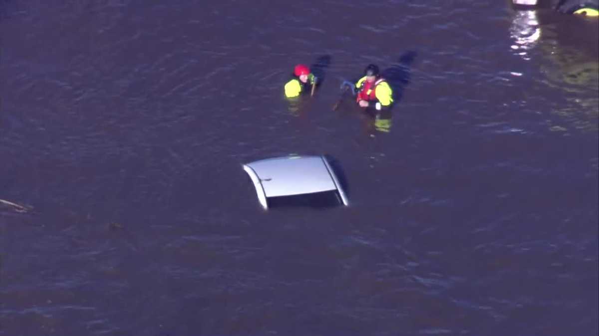
Northern California on Sunday will be mostly sunny but dealing with the aftermath of heavy rain and strong winds on Saturday that caused flooding and knocked out power for thousands.
Dozens of people were rescued after their cars got stuck on Highway 99 in Sacramento County when the Cosumnes River flooded the roadway south of Elk Grove. First responders are searching for a missing person. (Watch LiveCopter 3 footage in the video above.)
In the Sacramento area, more than 45,000 SMUD customers remained without power Sunday morning, down from 145,000, after winds toppled trees.
The Cosumnes River reached its highest level in history and brought flooding to Wilton and parts of south Sacramento County. Residents in Wilton were told to shelter in place if they haven’t already evacuated. Late Saturday, the National Weather Service issued a flash flood warning telling residents along the Cosumnes River at Cosumnes Road and Wilton Road to “seek higher ground immediately” due to the imminent risk of a levee failure.
The county confirmed Sunday that there has been a double levee breach.
This content is imported from Twitter.
You may be able to find the same content in another format, or you may be able to find more information, at their web site.
County officials have issued a local state of emergency and said they will be collecting damage estimates.
“Sacramento County has been experiencing an atmospheric river that began Dec. 31, 2022, and thus far has resulted in significant transportation impacts, rising creek and river levels and flooding in Wilton,” the county said.
Spokesperson Kim Nava said the proclamation will give the county’s director of emergency services the authority to fully use all county resources and personnel to assist with the emergency.
They could later seek reimbursement if a state or federal emergency proclamation is issued.
In the Sierra, chain controls are in effect on major highways after multiple spinouts and flooding caused traffic delays and closures on Saturday. (Look up the latest road information from Caltrans here.)
Interstate 80 and Highway 50 are back open.
This content is imported from Twitter.
You may be able to find the same content in another format, or you may be able to find more information, at their web site.
Happy New Year! What a NYE it was. Fortunately, the sun is back out in the Sierra and Interstate 80 reopened to traffic earlier this morning. Chain controls remain in effect. 50 is open as well with chain controls as crews clean up after the storm. @CHP_Truckee @CHPSouthLake pic.twitter.com/osmoTd0Ore
— Caltrans District 3 (@CaltransDist3) January 1, 2023
In El Dorado County, officials ordered evacuations in Cameron Park on Saturday as homes flooded. Some evacuation warnings in the area have since been lifted.
This content is imported from Facebook.
You may be able to find the same content in another format, or you may be able to find more information, at their web site.
This content is imported from Facebook.
You may be able to find the same content in another format, or you may be able to find more information, at their web site.
Here is the latest forecast for Northern California:
Meteorologist Eileen Javora said to expect mostly sunshine on Sunday and highs in the 50s.
The next weather system will move in on Monday. This system is much weaker than our recent storm. Rain amounts look to stay within .25-.50 of an inch for the Valley and Foothills. There will be snow in the Sierra with 6-10 inches falling at the summit and snow levels may lower to nearly 3,000 feet. Tuesday stays mainly dry and mostly cloudy. Our next storm moves in later Wednesday and into Thursday. This will likely bring an inch of rain to the Valley with 2-3 inches of rain possible for the Foothills. Snow in the Sierra may be heavy at times.
Here are the latest storm updates:
10:31 a.m.: Here is where Sac County’s flash flood warning extends.
This content is imported from Twitter.
You may be able to find the same content in another format, or you may be able to find more information, at their web site.
The @NWSSacramento has extended the flash flood warning from along the Cosumnes River at Cosumnes Road and Wilton Road to Highway 99 between Twin Cities Road and Dillard Road while local officials are assessing the situation. Please stay out of the affected area. pic.twitter.com/jN8CHap5Nh
— SacramentoOES (@SacramentoOES) January 1, 2023
10:27 a.m.: Some evacuation warnings have been lifted in Cameron Park.
This content is imported from Twitter.
You may be able to find the same content in another format, or you may be able to find more information, at their web site.
From @ElDoradoSheriff:
EVACUATION WARNING has been lifted for the following locations:
– Area between Cameron Park Lake and Piper Court, Cameron Park
– Area between Salida Way and Bonanza Drive, Cameron Park
– South of Sandridge Road and Highway 49 to the Amador County border
— County of El Dorado (@CountyElDorado) January 1, 2023
9:56 a.m.: Sacramento County officials confirm a double levee breach in the Wilton area.
9:53 a.m.: First responders are searching for a missing person near Highway 99 south of Elk Grove.
Caltrans says that Highway 99 is closed 1.4 miles south of Elk Grove at Dillard Road. It’s also closed to northbound traffic from the junction of State Route 104 to Mingo Road in Galt.
This content is imported from Twitter.
You may be able to find the same content in another format, or you may be able to find more information, at their web site.
Flash flooding continues in central/southern Sacramento County.
Numerous roads are underwater in, around & downstream of Wilton along the Cosumnes River, including CA-99 between Elk Grove & Galt.
DO NOT ATTEMPT TO DRIVE OVER FLOODED ROADWAYS – TURN AROUND, DON’T DROWN!#CAwx pic.twitter.com/p7ksZ1PZ1T
— NWS Sacramento (@NWSSacramento) January 1, 2023
8:27 a.m.: I-80 is back open for Sierra travel.
This content is imported from Twitter.
You may be able to find the same content in another format, or you may be able to find more information, at their web site.
‼️ UPDATE ‼️
01/01/23 6:45am
I-80 westbound and eastbound is NOW OPEN to passenger vehicles only, with R2 chain restrictions. The roads are extremely slick so let’s all work together and SLOW DOWN so we can keep I-80 open…
*for updates visit: https://t.co/nW388ezCE8 pic.twitter.com/J01R7IgsRA
— CHP Truckee (@CHP_Truckee) January 1, 2023
8:24 a.m.: SMUD is working to restore power but more than 43,000 people are still in the dark.
This content is imported from Twitter.
You may be able to find the same content in another format, or you may be able to find more information, at their web site.
SMUD crews have been working throughout the night to restore power. We still have areas that are impacted by last nights storm that brought very strong winds.
We’ve had reports of down power lines. If you come into contact with a down power line please avoid it and call 911.
— SMUD (@SMUDUpdates) January 1, 2023
12:47 a.m.: Here’s a look at precipitation totals.
This content is imported from Twitter.
You may be able to find the same content in another format, or you may be able to find more information, at their web site.
12:45 a.m.: Highway 50 is back open but I-80 remains closed.
This content is imported from Twitter.
You may be able to find the same content in another format, or you may be able to find more information, at their web site.
12:43 a.m.: SMUD’s outage map shows more than 88,000 customers still without power.
12:30 a.m.: The National Weather Service in Sacramento issued a flash flood warning late Saturday for residents in a part of Wilton to seek higher ground due to the imminent risk of levee failure.
The warning, which was issued after 11 p.m., is for residents along the Cosumnes River at Cosumnes Road and Wilton Road.
This content is imported from Twitter.
You may be able to find the same content in another format, or you may be able to find more information, at their web site.
Flash Flood Warning for Area of Wilton@NWSSacramento sent a flash flood warning to residents at Cosumnes Rd and Wilton Rd, due to an imminent levee failure in that area on the Cosumnes River. Residents have been advised to seek higher ground immediately. pic.twitter.com/EX6D6aQeGj
— Sacramento County (@SacCountyCA) January 1, 2023
8:33 p.m.: SMUD told KCRA 3 that power was out for 145,000 Sacramento area customers due to heavy windstorms causing trees in the area to fall and knock down power lines.
There is not yet a timetable for when power lines will be back up.
This content is imported from Twitter.
You may be able to find the same content in another format, or you may be able to find more information, at their web site.
6:27 p.m.: Caltrans is telling people not to travel to the Sierra tonight on I-80.
This content is imported from Twitter.
You may be able to find the same content in another format, or you may be able to find more information, at their web site.
6:14 p.m.: A viewer shared video showing flooding on Highway 99 in Modesto.
5:35 p.m.: Here’s a look at some of the storm impacts today across the region.
This content is imported from Facebook.
You may be able to find the same content in another format, or you may be able to find more information, at their web site.
5:33 p.m.: Liberty Utilities says there are more than 7,000 customers without power in South Lake Tahoe.
5:31 p.m.: Meteorologist Dirk Verdoon looks at rising water levels on the Cosumnes River
5:09 p.m.: KCRA 3’s Michelle Bandur reports that 150 people are under an evacuation order in Cameron Park.
5:08 p.m.: Sacramento County issues a proclamation of local state of emergency. The county’s office of emergency services will collect damage estimates.
4:28 p.m.: Part of Soda Springs Road in Nevada County is closed for flooding.
This content is imported from Twitter.
You may be able to find the same content in another format, or you may be able to find more information, at their web site.
UPDATE [4:20 p.m]: Soda Springs Road (Nevada County) is closed between the bridge and the railroad tracks as there is flooding in that area at this time. Please do not drive on any flooded roads.
— Placer Sheriff (@PlacerSheriff) January 1, 2023
4:17 p.m.: Here is an update for Highway 50.
This content is imported from Twitter.
You may be able to find the same content in another format, or you may be able to find more information, at their web site.
Current conditions on Highway 50 at the Twin Bridges chain checkpoint. Vehicles with AWD/FWD or chains allowed through but still HOLDING all traffic over the Summit for avalanche control work. pic.twitter.com/eE7cJoB0HY
— Caltrans District 3 (@CaltransDist3) January 1, 2023
This content is imported from Twitter.
You may be able to find the same content in another format, or you may be able to find more information, at their web site.
UPDATE: EB 50 traffic is back OPEN in Pollock Pines but HOLDING all traffic over Echo Summit for avalanche control. 80 traffic is being turned around EB in Colfax and WB at the state line. No ETO. pic.twitter.com/64Sy1j5eoR
— Caltrans District 3 (@CaltransDist3) December 31, 2022
4:10 p.m.: The El Dorado County Placerville Library is now closed as a temporary evacuation center, but the Cameron Park CSD is open at 2502 Country Club Drive.
4:05 p.m.: Meteorologist Dirk Verdoorn gives an update on where things stand with rain and flooding.
This content is imported from Facebook.
You may be able to find the same content in another format, or you may be able to find more information, at their web site.
3:59 p.m.: Here’s an update from Placer County.
This content is imported from Twitter.
You may be able to find the same content in another format, or you may be able to find more information, at their web site.
UPDATE Parts of Granite Bay may now be affected by rising waters. This includes Miners Ravine from Auburn-Folsom Road east to west at Sierra College Blvd (including Leilbinger, Miners Ravine, Itchy Acres, Carolinda, Tall Pine, Barton, Hardy, Shadow Oaks, and Cavitt Stallman)
— Placer Sheriff (@PlacerSheriff) December 31, 2022
3:55 p.m.: KCRA 3’s Lee Anne Denyer has an update on what’s happening in Wilton.
This content is imported from Facebook.
You may be able to find the same content in another format, or you may be able to find more information, at their web site.
3:52 p.m.: Highway 50 remains closed between Pollock Pines and Meyers due to flooding.
I-80 is closed from Colfax to the Nevada State Line due to multiple spinouts.
Get the latest from Caltrans.
This content is imported from Twitter.
You may be able to find the same content in another format, or you may be able to find more information, at their web site.
‼️ ROAD CLOSURE ‼️
12/31/22 3:50pm
I-80 is CLOSED westbound at the Nevada Stateline and eastbound at Colfax due spin outs, traffic collisions, and poor driving conditions. No estimated time of reopening.
*for updates visit: https://t.co/nW388ezCE8
— CHP Truckee (@CHP_Truckee) December 31, 2022
3:37 p.m.: Sacramento County emergency officials say that residents in Wilton should now shelter in place if they haven’t already left the area.
Read more.
This content is imported from Twitter.
You may be able to find the same content in another format, or you may be able to find more information, at their web site.
3:17 p.m.: Here’s a view from Jackson.
This content is imported from Twitter.
You may be able to find the same content in another format, or you may be able to find more information, at their web site.
2:29 p.m.: Here’s a look at flooding in Placerville.
This content is imported from Twitter.
You may be able to find the same content in another format, or you may be able to find more information, at their web site.
KCRA’s Michelle Bandur explains more in the video below:
2:27 p.m.: PG&E says there are more than 4,720 customers affected by an outage in Stockton.
2:13 p.m.: The Amador Fire Protection District says that they have responded to multiple water rescues and have assisted Jackson Fire with multiple flood calls.
Officials in Amador County advise people to stay home and avoid travel.
This content is imported from Twitter.
You may be able to find the same content in another format, or you may be able to find more information, at their web site.
The Amador County Sheriff’s Office of Emergency Services has opened a temporary evacuation point at the Italian Picnic Grounds.
See below for road closures in the county.
This content is imported from Facebook.
You may be able to find the same content in another format, or you may be able to find more information, at their web site.
2:11 p.m.: Here’s a look at how Arcade Creek, Cosumnes River and Deer Creek have risen above flood stage.
This content is imported from Twitter.
You may be able to find the same content in another format, or you may be able to find more information, at their web site.
2:05 p.m.: Here are more updates from Caltrans on road closures.
This content is imported from Twitter.
You may be able to find the same content in another format, or you may be able to find more information, at their web site.
This content is imported from Twitter.
You may be able to find the same content in another format, or you may be able to find more information, at their web site.
This content is imported from Twitter.
You may be able to find the same content in another format, or you may be able to find more information, at their web site.
2:02 p.m.: Arcade Creek in Sacramento County has reached the flood stage.
This content is imported from Twitter.
You may be able to find the same content in another format, or you may be able to find more information, at their web site.
1:59 p.m.: El Dorado and Sacramento Counties are adding more sandbag locations.
This content is imported from Facebook.
You may be able to find the same content in another format, or you may be able to find more information, at their web site.
Sacramento County’s new sandbag location is the Point Pleasant United Methodist Church, at 3329 Point Pleasant Road.
This content is imported from Twitter.
You may be able to find the same content in another format, or you may be able to find more information, at their web site.
5 sandbag locations are open for residents in the unincorporated county:
1. Branch Center (3847 Branch Center Rd.)
2. Orangevale Community Center (6826 Hazel Ave.)
3. Westside Park (6555 West 2nd St.)
4. Wilton Fire Station (10661 Alta Mesa Road) 🧵 pic.twitter.com/vsFzWX5Q5C
— Sacramento County (@SacCountyCA) December 31, 2022
1:56 p.m.: The El Dorado County Sheriff’s Office has ordered evacuations for Cameron Park in the area between Cameron Park Lake and Piper Court and Salida Way and Bonanza Drive.
This content is imported from Facebook.
You may be able to find the same content in another format, or you may be able to find more information, at their web site.
This content is imported from Facebook.
You may be able to find the same content in another format, or you may be able to find more information, at their web site.
Placerville Library is open as a temporary evacuation center at 345 Fair Lane, Placerville.
1:53 p.m.: Sacramento County’s Office of Emergency Services warned people who live in Wilton to evacuate the area on Saturday due to concerns of rising water blocking off roadways.
Sac County OES said in a release that there is an evacuation center in Elk Grove at the Wackford Community Center located at 9014 Bruceville Road.
The Cosumnes River level is continuing to rise throughout the day and is expected to crest above flood stage at 17. 5 feet around 5 p.m.
KCRA 3 meteorologist Eileen Javora said that the river hasn’t reached this level of flooding since 1997.
Read more here.
12:42 p.m.: El Dorado County announced where road closures are currently.
This content is imported from Twitter.
You may be able to find the same content in another format, or you may be able to find more information, at their web site.
11:30 a.m.: Cameron Park has flooded, causing some to leave the area.
This content is imported from Twitter.
You may be able to find the same content in another format, or you may be able to find more information, at their web site.
10:42 a.m.: Highway 50 is now being closed at Sly Park Road and at Meyers due to flooding.
This content is imported from Facebook.
You may be able to find the same content in another format, or you may be able to find more information, at their web site.
10:38 a.m.: NBC Bay Area reports thousands of people without power, roadways flooded in San Mateo and mudslides near Fremont, among other issues.
10:32 a.m.: Two people were rescued from the island in the middle of Laguna Creek in Elk Grove, Cosumnes Fire Department officials said.
This content is imported from Twitter.
You may be able to find the same content in another format, or you may be able to find more information, at their web site.
Two persons have been rescued by Rescue Boat 74 (IRB) from an island in the middle of Laguna Creek in Elk Grove near Bond and Waterman. All crews are out of the water and preparing for their next incident.
— Cosumnes Fire Dept. (@CosumnesFire) December 31, 2022
10:30 a.m.: All traffic is being held on westbound I-80 at the Nevada State Line due to spinouts over Donner Summit, Caltrans says.
Highway 50 is closed from Ice House Road to Meyers in El Dorado County due to flooding. Highway 49 is closed from San Ridge Road to Amador County.
Highway 89 is closed around Emerald Bay.
This content is imported from Twitter.
You may be able to find the same content in another format, or you may be able to find more information, at their web site.
9:53 a.m.: The Cosumnes Fire Department says some people are stuck on a temporary island in the middle of Laguna Creek in east Elk Grove.
This content is imported from Twitter.
You may be able to find the same content in another format, or you may be able to find more information, at their web site.
9:33 a.m.: Here’s a look at some of the other storm-related stories we’ve been following.
9:28 a.m.: Here’s a look at Deer Creek this morning.
This content is imported from Facebook.
You may be able to find the same content in another format, or you may be able to find more information, at their web site.
9:22 a.m.: Chief Meteorologist Mark Finan says flooding is expected later in Wilton and south Sacramento County.
This content is imported from Twitter.
You may be able to find the same content in another format, or you may be able to find more information, at their web site.
The Cosumnes River is above flood stage and won’t crest until this evening. This level can put water into homes in Wilton.
— Mark Finan (@kcraFinan) December 31, 2022
[/twitter]
9:09 a.m.: Here’s an update on Sierra chain controls and traffic issues.
Interstate 80: Eastbound I-80 traffic is being held at Nyack due to multiple spinouts. Chains are required from Nyack to the Nevada State Line.
Highway 50: Chains are required from Twin Bridges to Meyers. Caltrans’ camera shows eastbound Highway 50 closed at Ice House Road, west of Whitehall. KCRA 3 is trying to learn more about this.
This content is imported from Twitter.
You may be able to find the same content in another format, or you may be able to find more information, at their web site.
8:48 a.m.: In the videos below, KCRA 3’s Mike TeSelle gives an update from Arcade Creek at Winding Road. The creek is swelling but has not caused flooding at this time.
This content is imported from Twitter.
You may be able to find the same content in another format, or you may be able to find more information, at their web site.
8:46 a.m.: In the video below, Meteorologist Eileen Javora gives an update on rain totals so far and you can see water flowing from the Foothills down Deer Creek in eastern Sacramento County.
8:37 a.m.: Stockton police warn drivers to stay away from the Hammer Lane underpass at the railroad tracks east of Lorraine Avenue.
This content is imported from Twitter.
You may be able to find the same content in another format, or you may be able to find more information, at their web site.
Street Flooding Alert
Please avoid the area of the Hammer Ln underpass at the RR tracks just east of Lorraine Ave due to heavy flooding. City crews are on their way.
Also, do not attempt to drive through flooded roadways. Always choose a different route to avoid getting stuck. pic.twitter.com/aK11kqzqe8
— Stockton Police Dept (@StocktonPolice) December 31, 2022
8:34 a.m.: El Dorado County fire officials warn about roadway flooding and rock slides.
This content is imported from Facebook.
You may be able to find the same content in another format, or you may be able to find more information, at their web site.
8:09 a.m.: KCRA 3’s Mike TeSelle has an update on a downed tree in the roadway in Carmichael.
This content is imported from Twitter.
You may be able to find the same content in another format, or you may be able to find more information, at their web site.
8:08 a.m.: An update on Folsom Lake.
This content is imported from Twitter.
You may be able to find the same content in another format, or you may be able to find more information, at their web site.
Folsom Lake now rising at 1 foot per hour even with releases going on
— Mark Finan (@kcraFinan) December 31, 2022
7:55 a.m.: Viewer Nancy Riedell in Citrus Heights sent this photo of what conditions look like at Arcade Creek.
Nancy Riedell
Arcade Creek
7:35 a.m.: Reports of flooding on roadways this morning.
This content is imported from Twitter.
You may be able to find the same content in another format, or you may be able to find more information, at their web site.
This content is imported from Twitter.
You may be able to find the same content in another format, or you may be able to find more information, at their web site.
7:39 a.m.: Chain controls are in effect on I-80 eastbound from Kingvale in Placer County to Hirschdale Road in Truckee, Caltrans said.
Westbound chain controls are from Truckee to 4.7 miles west of Kingvale.
Chain controls are also in effect on Highway 50 from Twin Bridges to Meyers in El Dorado County.
Track the latest highway information here.
7:36 a.m.: A warning to turn around if you see flooded roads.
This content is imported from Twitter.
You may be able to find the same content in another format, or you may be able to find more information, at their web site.
7 a.m.: Several teens were rescued from tree limbs after their car was stuck on Scott Road at Deer Creek around 1 a.m., Sacramento Metro Fire said.
This content is imported from Twitter.
You may be able to find the same content in another format, or you may be able to find more information, at their web site.
6:48 a.m.: Meteorologist Eileen Javora says Cosumnes River was at flood stage at 13 feet at Michigan Bar, as of 5 a.m. It is forecast to crest at 15.5 feet at 9 p.m., which is higher than previously anticipated. That means property in and possibly houses near and around the town of Wilton may be impacted.
6:02 p.m.: Check out the increase in rain totals as of 6 p.m.
This content is imported from Twitter.
You may be able to find the same content in another format, or you may be able to find more information, at their web site.
5:28 p.m.: Here’s an update on rain totals as of 5 p.m.
This content is imported from Twitter.
You may be able to find the same content in another format, or you may be able to find more information, at their web site.
5:15 p.m.: Melanie Wingo shows you what it looks like near Deer Creek in Sacramento County.
This content is imported from Facebook.
You may be able to find the same content in another format, or you may be able to find more information, at their web site.
4:36 p.m.: Here’s an update from the National Weather Service in Reno.
This content is imported from Twitter.
You may be able to find the same content in another format, or you may be able to find more information, at their web site.
Flooding is possible due to heavy rainfall and runoff in northeast California, the Sierra Nevada, and western Nevada. Urban, poor drainage area, and small stream flooding are very likely, with major rises expected on mainstem rivers with minor-to-moderate flooding possible. pic.twitter.com/d6xwHqQhca
— NWS Reno (@NWSReno) December 31, 2022
4:29 p.m.: Chief Meteorologist Mark Finan explains in the video below where flood-prone areas are. He says places to keep an eye on over the weekend include areas near Dry Creek, Arcade Creek and Deer Creek.
4:24 p.m.: KCRA 3’s Melanie Wingo reports from the Rancho Murieta area, where there is some localized street flooding on Kiefer Boulevard near Deer Creek. She was there when a tow company was called out to assist a stuck motorist.
4:13 p.m.: Chief Meteorologist Mark Finan says there has been light rain in the Valley, but it’s been raining all day long in the Foothills. Rain totals tell the story.

2:17 p.m.: El Dorado County residents are told to buy sandbags at home improvement stores if needed.
This content is imported from Facebook.
You may be able to find the same content in another format, or you may be able to find more information, at their web site.
1:38 p.m.: CHP’s East Sacramento and Oroville accounts on Facebook are warning of flooding on some roadways.
This content is imported from Facebook.
You may be able to find the same content in another format, or you may be able to find more information, at their web site.
This content is imported from Facebook.
You may be able to find the same content in another format, or you may be able to find more information, at their web site.
1 p.m.: Here’s a look at what conditions looked like in the noon hour.
9 a.m.: The National Weather Service shares a look at the radar and warns of flooding in areas with heavy rain.
This content is imported from Twitter.
You may be able to find the same content in another format, or you may be able to find more information, at their web site.
Moderate to heavy rain will impact northern California today – tomorrow, especially in the foothills & mountains. Snow levels will be above pass level today, slowly falling tomorrow. Here’s a look at forecast radar. Flooding is possible in areas of heavy rain. Be prepared! #CAwx pic.twitter.com/dGswwKyYrE
— NWS Sacramento (@NWSSacramento) December 30, 2022
8:05 a.m.: Meteorologist Heather Waldman walks you through rain totals from earlier in the week and takes a look at futurecast for the upcoming storm.
Video Below: Chief Meteorologist Mark Finan explains what to know about possible flooding concerns this weekend in Northern California
Download our app for the latest
Here is where you can download our app for the latest weather alerts.
Follow our KCRA weather team on social media
Watch our forecasts on TV or online
Here’s where to find our latest video forecast. You can also watch a livestream of our latest newscast here. The banner on our website turns red when we’re live.
We’re also streaming on the Very Local app for Roku, Apple TV or Amazon Fire TV.
Track Northern California Doppler radar here
(App users, click here to see our interactive radar map.)
Track real-time traffic updates here
(App users, click here to see our interactive traffic map.)